The Choice for the Right-of-Way
On the 3.5-mile abandoned Rockaway Beach Branch rail corridor, why Queens should keep the rails for a subway and build the trails alongside, rather than tear out the rails for a trail alone.
A 3.5-mile abandoned right-of-way through Queens. A choice that closes in late June 2026. A decision that will shape the borough for a century.
Chapter One
Queens as a Transit Desert
The most populous borough outside Manhattan has the fewest subway stations per capita in New York City.
Subway stations per resident
Chapter Two
The Abandoned Right-of-Way
Queens has no direct subway connection between its northern and southern neighborhoods. A trip from Forest Hills to the Rockaways, two parts of the same borough, requires going through Manhattan and back.
But there is an existing solution. A right-of-way is a strip of land legally reserved for transportation use. The City has owned one running 3.5 miles through the heart of Queens since the LIRR Rockaway Beach Branch last ran revenue service on
June 9, 1962.
The Rockaway Beach Branch in context
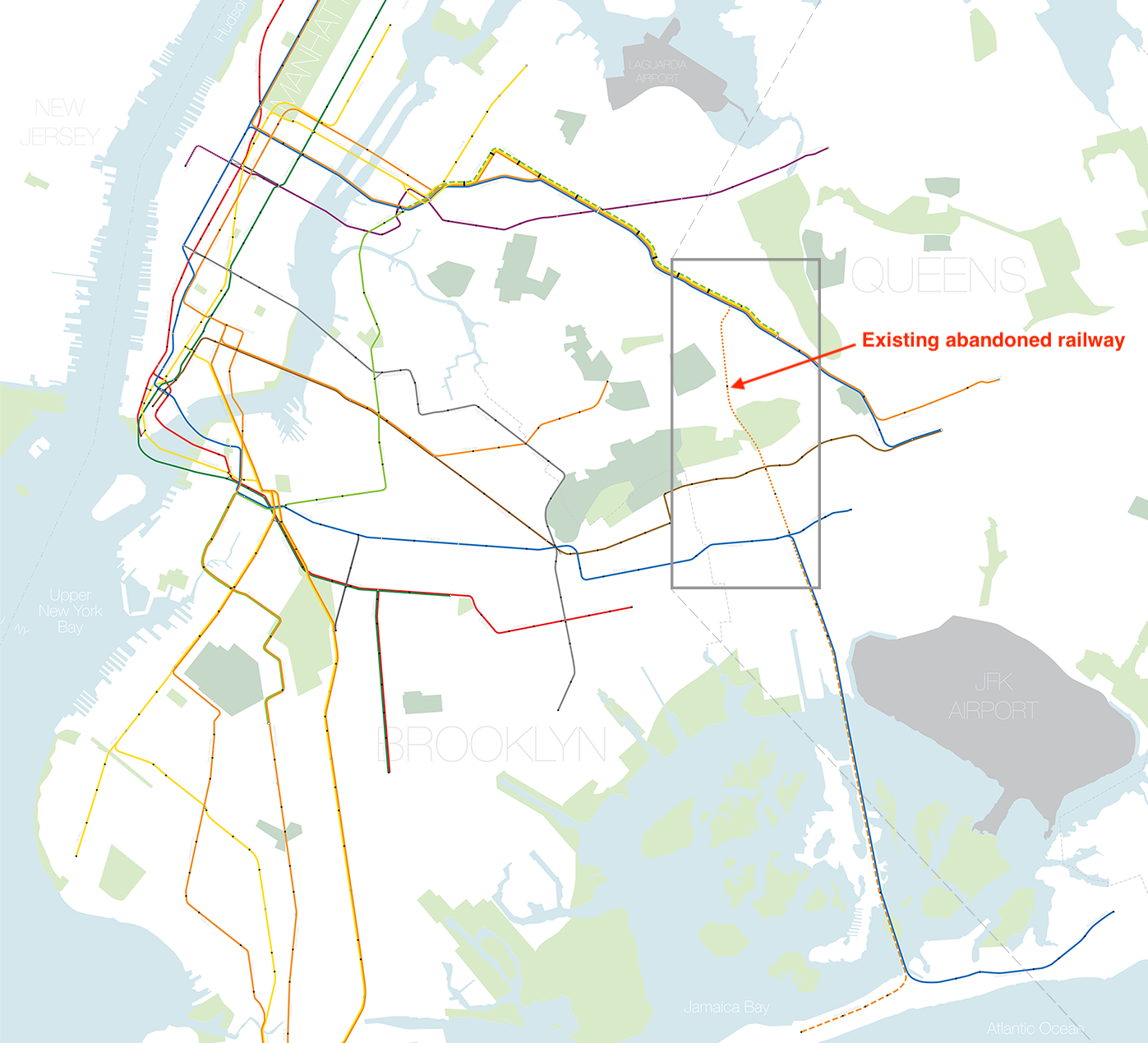
Map: Andrew Lynch / vanshnookenraggen.com
For 64 years, the City has retained this right-of-way with much of the original railway infrastructure remaining in place. It runs 3.5 miles through the heart of Queens. The question is what to build on it.
The dormant corridor could potentially connect existing subway infrastructure at three points: the M/R at Rego Park, the J/Z at Woodhaven Boulevard, and the A train to the Rockaways.
However, there are plans in motion called QueensWay to build a park strip that removes the dormant track infrastructure in favor of a linear park in the style of the High Line.
In contrast, QueensLink calls to reactivate the existing railway infrastructure and connect a north–south corridor for the subway.
Chapter Three
What Are the Options
QueensLink
A rails-and-trails approach: subway service through the corridor with a 33-acre linear park alongside.
QueensWay
A park-only design inspired by the High Line: the entire right-of-way converted to green space.
Both proposals address the corridor. QueensLink is complementary to the proposed , which serves different geography connecting Brooklyn and Queens via existing freight right-of-way.
Chapter Four
The Strongest Case for the Park Alone
Queens is park-poor. The federal grant that funded QueensWay's Phase 2 was an environmental-justice instrument. The MTA's capital pipeline is oversubscribed and QueensLink is not guaranteed a place in it. A park-now may be more honest than a subway-someday — and this is a real argument.
But QueensLink's proposal already includes a 33-acre linear park alongside the rail. The choice is not park vs. transit. It is a park design that forecloses transit, or one that does not.
Central Queens has less accessible open space than its population density warrants. The Trust for Public Land's ParkScore NYC 2024 documents the gap. Friends of the QueensWay, founded in 2011 in partnership with TPL, predates the current political fight (QNS, September 19, 2022; TPL project page). The $117 million federal Reconnecting Communities grant that funded Phase 2 was explicitly an environmental-justice instrument under the Inflation Reduction Act (Meng/Meeks/Velázquez press release, March 13, 2024) — since rescinded in July 2025 under the One Big Beautiful Bill Act (Crain's New York, 2025), with $14 million in city capital allocated to backfill (Queens Daily Eagle, October 8, 2025). Treating QueensWay supporters as cover for exclusionary politics is a category error.
The MTA's capital pipeline is genuinely oversubscribed. Second Avenue Subway Phase 2, IBX (approximately $5.5 billion), Penn Access, the Hudson tunnels, Sandy resilience, signal modernization, accessibility upgrades — the list is long, the budget is not infinite, and QueensLink's inclusion in the 2030–2034 Capital Plan is not guaranteed. The IBC itself flags this window (Steer, 2026, p.6). A park-now may be more honest than a subway-someday. This is a real argument and not a stupid one.
But QueensLink's own proposal already includes a 33-acre linear park alongside the rail (Steer, 2026, Executive Summary p.8, §3.1). The foreclosure problem is specifically about the Metropolitan Hub's current design occupying the corridor's critical construction staging point — not about parks on the corridor in principle. The choice is not "park vs. transit." It is a park design that forecloses transit vs. a park design that does not.
QueensLink has published an alternative Metropolitan Hub design that moves the path off the embankment, preserves a continuous bridge connection over the LIRR tracks, and leaves room for future transit construction (queenslink.org, April 2026). The alternative design, the coalition, and the letter tool that reaches the Mayor's office during the FY27 budget negotiation are at queenslink.org. The foreclosure argument that motivates them follows in Chapter 8.
Primary sources
- Steer Group. (2026). QueensLink Initial Business Case. Executive Summary, §3.1. thequeenslink.org/reports-studies
- Trust for Public Land. (2026). QueensWay Project. tpl.org/our-work/queensway-project
- MTA. (2025). 2025–2029 Capital Program / 20-Year Needs Assessment. new.mta.info
- Meng, G., Meeks, G., & Velázquez, N. (2024, March 13). Press release. meng.house.gov
Secondary
- Crain's New York Business. (2025, July 29). NYC loses $112M in federal money for Queensway park. crainsnewyork.com
- Queens Daily Eagle. (2025, October 8). City plants funds into QueensWay after feds cut cash. queenseagle.com
- QNS. (2022, September 19). Friends of the QueensWay founding context. qns.com
Chapter Five
Who Lives Here
880,000
Queens residents
live within a 15-minute walking distance of the corridor QueensLink and its extensions would serve. This is more than the entire population of San Francisco.
Source: Steer IBC §2.3; San Francisco population per US Census 2020
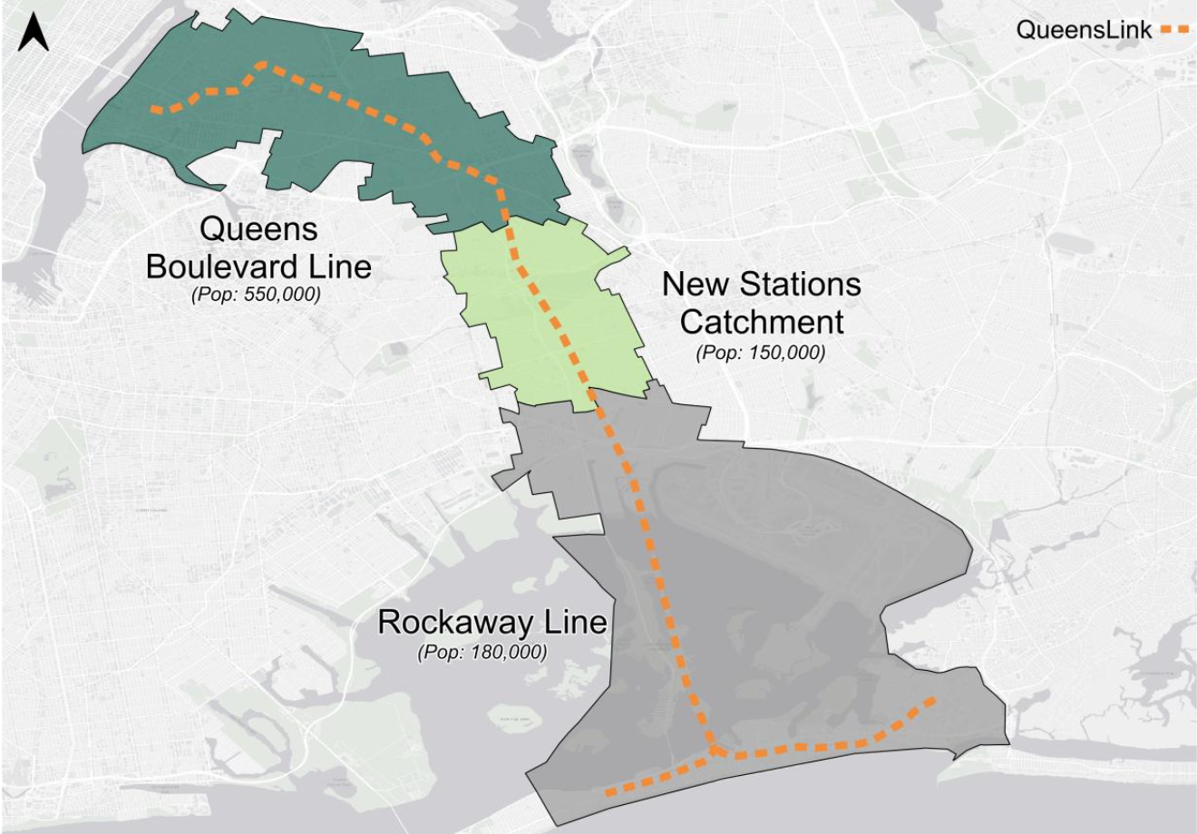
Households without a car — Queens Boulevard Line corridor
For more than half of residents along this corridor, transit is not a convenience: it is the ONLY option.
Source: Steer IBC Table 2.2
Low-income household rate
These are the households least able to absorb the cost of car ownership. Without viable transit, there is no alternative.
Source: Steer IBC Table 2.2
Northern Elmhurst to the Rockaways
68
minutes today
42
with QueensLink
A trip from Northern Elmhurst to the Rockaways takes 68 minutes by transit today. With QueensLink, it would take 42 minutes. A resident who cannot reach a job, a hospital, or a school in a reasonable time because the same journey takes over an hour faces a barrier that does not appear in any budget line. The difference is not convenience — it is access to opportunity.
Source: Steer IBC Figure 4.2, p.41
Jim Burke, a former Rockaways resident now living in Jackson Heights, takes the Q53 bus several times a week to visit his family in the borough's southeastern corner. He's been riding the line since the 1970s.
"The Q53 bus was a temporary stopgap measure, to replace the Rockaway train that used to come that exact route. But it's slow, it's crowded. The bus lane is only in effect from 4 to 7 p.m."
"Being able to hop on a subway close to your door and get in and get to Brooklyn, get to Manhattan, get to other parts of Queens. That's what makes New York City, right?"
Chapter Six
Where Is the City Going
Adams administration
- $35M allocated for QueensWay Phase 1 (September 2022)
- $117M federal Reconnecting Communities grant secured (March 2024) — rescinded July 2025 under the One Big Beautiful Bill Act
NYC Backfill
- $14M city capital allocated to replace federal funding (FY26 September Capital Commitment Plan, October 2025)
Mamdani administration
- $43M in preliminary FY27 budget for QueensWay Metropolitan Hub (March 2026, subject to Council negotiation)
QueensLink
- $0.4M federal DOT planning grant + $0.1M NY State match (Assemblywoman Stacey Pheffer Amato)
- Initial Business Case self-funded via GoFundMe (March 2026, Steer Group)
Total public funding committed/proposed
QueensWay total reflects $117M federal grant rescission.
The City has committed or proposed approximately $92M to the park-only design. The rails-and-trails alternative received a modest planning grant. A $117M federal grant for QueensWay was rescinded in July 2025 — removing the financial backbone of the park-only plan and opening a window to pivot toward transit reactivation.
That window was not taken.
Sources: Crain's NY, 29 July 2025; Queens Daily Eagle, 8 October 2025; 21 July 2025; NY State Assembly press release
Chapter Seven
The Implications
74,600
Daily riders (2040)
969K
Person-minutes daily time savings
1.10
Benefit-Cost Ratio, Core Scenario
Economic Analysis
$6.78B
Total societal benefit
1.10
Benefit-cost ratio
$600M
Net present value
Net present value: $600 million. Evaluation period: 2035–2065, discounted at 3.0% in 2025 dollars.
According to the Steer Group Initial Business Case, QueensLink generates $1.10 in societal benefit for every dollar of lifecycle cost — capital, operations, and maintenance over 30 years.
Source: Steer IBC §11.1, Figure 11.1
Chapter Eight
A Pattern New York Has Seen Before
Infrastructure encodes political choices into the physical city for generations. New York has been here before.
Once built, it stays built
When Robert Moses chose the route for the Cross Bronx Expressway in 1955, he rejected an alternative that would have caused significantly less displacement. Once constructed, the expressway permanently altered the Bronx — not because future mayors agreed with the decision, but because the cost of undoing it exceeded the cost of living with it. The decision was encoded in concrete.
The principle applies to any irreversible infrastructure choice. QueensLink supporters argue the Metropolitan Hub, as designed, occupies the primary staging ground for any future RBB reactivation. The Metropolitan Avenue station site sits at the heart of the corridor's planned construction sequence. A Streetsblog NYC feature in May 2026 examined comparable projects in Maryland and Atlanta where rail-trail conversions significantly complicated subsequent transit construction.
Sources: Robert Caro, The Power Broker (1974); Streetsblog NYC, 12 May 2026; QueensLink spokesperson Noelle Hunter, quoted in Streetsblog NYC, 12 May 2026
Who bears the cost
The communities adjacent to the Metropolitan Hub, Forest Hills and Rego Park, have above-median household incomes and above-average car ownership. They gain a park. The communities QueensLink would most directly serve, the new station catchment and the Rockaways, have higher rates of low income and lower car ownership. They gain transit access, or they don't.
This is not a claim about intent. It is an observation about distribution. The park primarily benefits those who need it least for mobility. The subway primarily benefits those who have no alternative.
Communities adjacent to the Metropolitan Hub
- •Forest Hills / Rego Park: above Queens median household income
- •Car ownership: above Queens average
- •Existing subway access: E, F, M, R within walking distance
Communities QueensLink would serve
- •New station catchment: 11% low-income households
- •Rockaway catchment: 18% low-income (vs 13% Queens average, 17% NYC average)
- •Queens Boulevard corridor: 56% of households have no car
Source: Steer IBC Table 2.2, p.16; US Census Bureau ACS 2023
The contested question
The city's position, articulated by Deputy Mayor Meera Joshi under both Adams and Mamdani, has been that QueensWay would not preclude future transit.
Streetsblog noted: "the city's most recent designs of the Metropolitan Hub show the park pretty firmly entrenched in areas that the train project would have to subsume."
QueensLink spokesperson Noelle Hunter, quoted in Streetsblog NYC (12 May 2026): the Metro Hub location is "the winch point of the project. It involves the Metropolitan Avenue Station, and we've identified it the primary staging grounds for construction."
Sources: Streetsblog NYC, 25 March 2026; Streetsblog NYC, 12 May 2026
The asymmetry of reversal
A subway can coexist with a linear park — QueensLink's own proposal includes a 33-acre park alongside the rail. A park built on the rail alignment, however, creates a constituency, a maintenance obligation, and a demolition cost that did not exist before.
This is not a claim that foreclosure is certain. It is an observation that the two options are not symmetrically reversible. Building transit first preserves the option of a park. Building a park first raises the cost of transit.
Sources: Steer IBC Exec Summary, p.8 (33-acre linear park); Streetsblog NYC, 12 May 2026 (Maryland Purple Line, Atlanta Beltline comparisons)
The window that closes
In 1985, a proposed Lower Manhattan highway called Westway was defeated in federal court after years of advocacy — before construction began. The $1.7 billion in federal highway funds was redirected to the MTA, funding transit improvements that still benefit New York today. Westway could be stopped because no concrete had been poured.
The Metropolitan Hub is scheduled to break ground in 2026. QueensLink supporters identify the Metropolitan Avenue station site as the corridor's critical constraint point. Once construction begins, the structural cost of reversing course — financial, political, logistical — compounds in the same way it did after the Cross Bronx Expressway was poured. The window does not stay open indefinitely.
Sources: Federal Highway Administration, Westway project records; Streetsblog NYC, 12 May 2026; QueensLink spokesperson Noelle Hunter, quoted in Streetsblog NYC, 12 May 2026
Chapter Nine
How to Help
The $43 million Metropolitan Hub line item is in the City's preliminary FY27 budget. Between now and the Adopted Budget — typically finalized in late June — the City Council negotiates the final number with the Mayor's office. That is the window.
QueensLink maintains the campaign infrastructure: a letter tool routed to the Mayor and the relevant Council members, the alternative Met Hub design, the coalition list, the Steer report, and the press archive.
If you live in Queens, your Council member votes on the Adopted Budget and the letter tool will find them. If you don't, put this page in front of someone who does. 880,000 people live within 15 minutes of walking from the corridor — most of them don't know the report exists.
The corridor has waited 64 years. The decision about what to build will shape Queens for the next century.
Chapter Ten
For the Record
Whatever decision is ultimately made about the Rockaway Beach Branch corridor, this page will remain as a public record.
It documents who held authority over this decision, what alternatives were available, what evidence existed at the time, and which path was chosen. The bare facts have been laid out: the funding figures, the ridership projections, the opportunity costs, and the moments where different choices were possible.
The rest is for the public to judge — now, and in the years to come.
Accountability requires memory. This is ours.